
Utrecht › About the city
This is Utrecht
Utrecht lies in the middle of the Netherlands, where the Romans once guarded the Rhine. For a thousand years it was the seat of the bishops who brought Christianity to the north, and its old town still turns round the Dom Tower, the tallest church tower in the country. Its medieval canals run low between quays with cellars under the street, and today it is a busy university town where most people get about by bike.
Photo: Michielverbeek, CC BY-SA 4.0, via Wikimedia Commons

Utrecht at a glance
- Country
- Netherlands
- Province
- Utrecht, of which it is the capital
- Population
- About 370,000 (city)
- Rivers
- The Kromme Rijn and the Vecht, linked by the canals of the old town
- Founded
- As a Roman fort on the Rhine, about AD 47
- University
- Utrecht University, founded in 1636
- World Heritage
- The Rietveld Schröder House (2000) and the Roman fort under the Domplein, part of the Lower German Limes (2021)
- Nickname
- De Domstad, the city of the Dom
Known for
- The Dom Tower, 112 metres tall, standing apart from its church
- The Oudegracht, the canal with its wharf cellars and terraces at the water
- The Union of Utrecht of 1579 and the Treaty of Utrecht of 1713
- Miffy, the rabbit Dick Bruna drew here
- Gerrit Rietveld’s Red Blue Chair and Schröder House
- The biggest bike park in the world, under the station
The city
Utrecht’s old town is an oval ringed by its old moat, the Singel, and cut through from south to north by the Oudegracht. The Dom Tower and the Domplein lie at its heart, with the four churches that Bishop Bernold set round the cathedral in a cross: the Pieterskerk, the Janskerk and two that are gone. The Nieuwegracht and the Kromme Nieuwegracht run through the quieter, leafy east of it, past canons’ houses and the Paushuize.
Instant Utrecht takes you round that heart: from the flower market on the Janskerkhof along the Drift and the Kromme Nieuwegracht, past the Pieterskerk and the Paushuize, through the Domplein below the tower, and along the Vismarkt by the Oudegracht and back. The country is flat, and so is the game.
Where it lies
Utrecht lies at the centre of the Netherlands, about 40 kilometres south-east of Amsterdam, where the old course of the Rhine, now the Kromme Rijn, meets the Vecht. Round it lie the wooded sand ridge of the Utrechtse Heuvelrug to the east, the peat meadows and lakes to the north and west, and a ring of new suburbs, Leidsche Rijn the largest.
Its station, Utrecht Centraal, is the busiest railway hub of the country, where the lines from every direction meet, and its bike park under the station square holds 12,500 bikes. The climate is mild and damp, with cool summers and winters that rarely freeze for long.
Places and landmarks
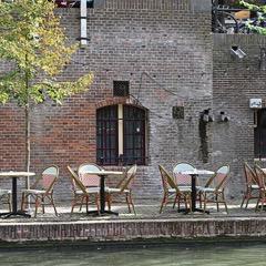 OudegrachtUtrecht’s medieval canal, with its quays down at the water and the old cellars under the street now full of cafés.
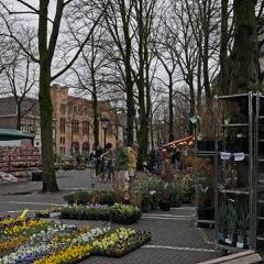 JanskerkhofThe leafy square round the Janskerk, with a flower market every Saturday.
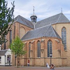 PieterskerkOne of the oldest churches in the Netherlands, a Romanesque church of 1048 with a crypt under its choir.
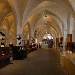 Museum SpeelklokA museum of self-playing music, from music boxes to great dance organs, inside the medieval Buurkerk.
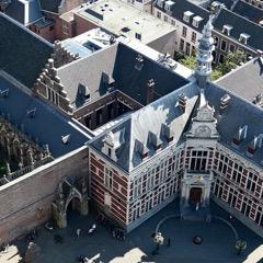 AcademiegebouwThe main building of Utrecht University on the Domplein, where the Union of Utrecht was signed in 1579.
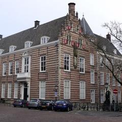 PaushuizeThe house on the Kromme Nieuwegracht built for Adrian of Utrecht, who became the only Dutch pope.
The centre on a map
The streets, squares and waterways every visitor to Utrecht ends up in. Point at one to find it on the map.

-
1
Dom Tower Domtoren building
The tallest church tower in the country, 112 metres, with 465 steps to the top.
-
2
Domplein square
The square where the nave of the cathedral stood until 1674, over the Roman fort.
-
3
Dom Church Domkerk building
The choir and transept of the Gothic cathedral.
-
4
Pandhof park
The cloister garden of medieval herbs beside the Dom Church.
-
5
Oudegracht waterway
The medieval canal with its wharf cellars and terraces at the water.
-
6
Vismarkt street
The old fish market along the Oudegracht, below the Dom Tower.
-
7
Kromme Nieuwegracht waterway
The quiet, curving canal past the Pieterskerk and the Paushuize.
-
8
Janskerkhof square
The square round the Janskerk, with its Saturday flower market.
-
9
Pieterskerk building
The Romanesque church of 1048.
-
10
Paushuize building
The house built for the only Dutch pope.
-
11
Academiegebouw building
The university’s main building, where the Union of Utrecht was signed.
-
12
Museum Speelklok building
The museum of self-playing music in the Buurkerk.
-
13
Stadhuis building
The town hall on the Oudegracht, a row of medieval houses behind one front.
-
14
Museum Catharijneconvent building
The national museum of Christian art in a medieval convent.
-
15
Centraal Museum building
The oldest city museum in the country, with Rietveld and the Utrecht Caravaggisti.
History
A Roman fort and the first bishops
Around AD 47 the Romans built a fort on the Rhine here, Traiectum, the ford, as part of the Limes, the frontier of their empire. Its remains lie under the Domplein.
In 695 the English monk Willibrord came to convert the Frisians and made the old fort his base. From then on Utrecht was the seat of the bishops of the north, who became powerful lords as well, ruling a large state of their own. The town got its rights in 1122 and grew rich on the trade along the Rhine.
A town of churches
In the 11th century Bishop Bernold built four churches round the cathedral in the shape of a cross. In 1254 work began on a new, Gothic cathedral, and from 1321 on its tower, finished in 1382. Utrecht had so many churches, chapels and convents that its skyline was a forest of spires.
In 1528 the bishop handed his worldly power to the emperor Charles V, and the province of Utrecht became one of the Habsburg Netherlands. Adrian of Utrecht, Charles’s old teacher, became pope in 1522.
Union and treaty
In 1579 the northern provinces signed the Union of Utrecht in the cathedral’s chapter house, joining together against Spain. The pact became the basis of the Dutch Republic, and the town turned Protestant. The university followed in 1636.
In 1674 a storm blew down the nave of the cathedral and left the tower on its own. In 1713 the powers of Europe met here to sign the Treaty of Utrecht, which ended the War of the Spanish Succession.
Rail hub and university town
In the 19th century the railways made Utrecht the crossroads of the country, and the town grew far beyond its moat. In the 1970s part of the Singel was filled in for a motorway; it was dug out again and filled with water in 2020.
In the 20th century Gerrit Rietveld built his Schröder House on the edge of town and Dick Bruna drew Miffy here. Today the university and the colleges bring tens of thousands of students to the town.
Utrecht today
Utrecht is one of the fastest-growing towns in the country, a university and service town at the centre of the rail network. Most people get about by bike, and the old town is closed to most cars.
In the evening the terraces on the wharves of the Oudegracht fill up, on Saturday the flower market spreads over the Janskerkhof, and on summer nights the Trajectum Lumen walk lights up the bridges, wharves and church walls of the old town.
Read on
- Gemeente Utrecht The city council (in Dutch)
- Domtoren Tickets for a tour up the tower
- Centraal Museum The city museum, with the Miffy Museum
- Utrecht on Wikipedia The encyclopedia article