
Istanbul › About the city
This is Istanbul
Istanbul lies on both banks of the Bosphorus, the strait between the Black Sea and the Sea of Marmara, half in Europe and half in Asia. For sixteen centuries it was a capital, of the Roman and Byzantine emperors as Constantinople and of the Ottoman sultans after them. Its old peninsula, between the Golden Horn and the sea, holds the Hagia Sophia, the Blue Mosque, Topkapı Palace and the Grand Bazaar. Today it is the largest city of Turkey, with more than fifteen million people.
Photo: Maksym Kozlenko, CC BY-SA 4.0, via Wikimedia Commons

Istanbul at a glance
- Country
- Turkey
- Province
- İstanbul
- Population
- About 15.7 million (province)
- Lies
- On both sides of the Bosphorus, between the Black Sea and the Sea of Marmara
- Height
- From sea level up the seven hills of the old city, to about 60 metres
- Language
- Turkish
- Known for
- The Hagia Sophia, the Blue Mosque, the bazaars, the Bosphorus
- Founded
- As Byzantium, by Greek settlers, in the 7th century BC
Known for
- The Hagia Sophia, a church for nine hundred years, then a mosque
- The Blue Mosque and the skyline of domes and minarets
- Topkapı Palace, home of the Ottoman sultans
- The Grand Bazaar and the Spice Bazaar
- The ferries across the Bosphorus, between Europe and Asia
- Simit, Turkish tea and Turkish delight
The city
The old city of Istanbul is a peninsula shaped like a horn, with the Golden Horn to the north, the Sea of Marmara to the south and the Bosphorus at its tip. On its point lies Topkapı Palace above Gülhane Park, and just inland the Hagia Sophia and the Blue Mosque face each other across Sultanahmet Square, with the long Hippodrome beside them. From there the Divan Yolu, the old imperial road, runs west past the Column of Constantine to the Grand Bazaar, while the streets to the north fall steeply down to Sirkeci, Eminönü, the New Mosque and the Spice Bazaar on the shore of the Golden Horn, where the Galata Bridge crosses to Karaköy.
Instant Istanbul takes you through the heart of it: from the Hagia Sophia along the Divan Yolu to the Column of Constantine and the gate of the Grand Bazaar, down the Ankara Caddesi to Sirkeci, and back along the tram past Gülhane Park and down the lane of wooden houses to the gate of Topkapı Palace. The real streets climb and fall over the hills; in the game the city is flat.
Where it lies
Istanbul spreads along the Bosphorus, the 30-kilometre strait that joins the Black Sea to the Sea of Marmara and divides Europe from Asia. On the European side the Golden Horn, a long inlet, cuts the old city off from Galata and Beyoğlu to the north. Three bridges and two tunnels cross the Bosphorus, and the ferries cross it all day.
The climate lies between that of the Mediterranean and the Black Sea: hot, humid summers, cool and wet winters with now and then snow, and winds that blow down the Bosphorus from the north.
Places and landmarks
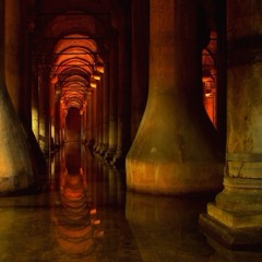 Basilica CisternThe underground water store of Justinian, a forest of 336 columns standing in the water.
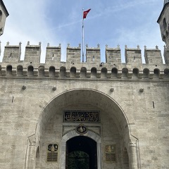 Topkapı PalaceThe palace of the Ottoman sultans for almost four hundred years, on the tip of the peninsula above the Bosphorus.
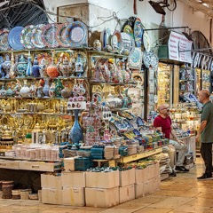 Grand BazaarOne of the oldest and largest covered markets in the world, some sixty streets and four thousand shops under one roof.
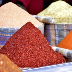 Spice BazaarThe L-shaped covered market by the New Mosque, full of spices, dried fruit, tea and Turkish delight.
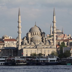 New MosqueThe great mosque on the water at Eminönü, begun in 1597 and finished 68 years later.
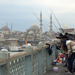 Galata BridgeThe bridge over the Golden Horn from Eminönü to Karaköy, lined with anglers on top and fish restaurants below.
The centre on a map
The streets, squares and waterways every visitor to Istanbul ends up in. Point at one to find it on the map.

-
1
Hagia Sophia Ayasofya building
Justinian’s great domed church of 537, now a mosque.
-
2
Blue Mosque Sultanahmet Camii building
The mosque of Ahmed I, with six minarets and blue İznik tiles.
-
3
Hippodrome At Meydanı square
The old chariot track, with its obelisk and serpent column.
-
4
Basilica Cistern Yerebatan Sarnıcı building
Justinian’s underground water store of 336 columns.
-
5
Topkapı Palace Topkapı Sarayı building
The palace of the Ottoman sultans, on the tip of the peninsula.
-
6
Soğukçeşme Sokağı street
A lane of restored wooden houses along the palace wall.
-
7
Gülhane Park Gülhane Parkı park
The palace’s old outer garden, sloping down to the Bosphorus.
-
8
Divan Yolu Divanyolu Caddesi street
The old imperial road from the Hagia Sophia west, with the tram.
-
9
Column of Constantine Çemberlitaş building
Constantine’s porphyry column of 330, held by iron hoops.
-
10
Grand Bazaar Kapalıçarşı building
Sixty covered streets and four thousand shops.
-
11
Ankara Caddesi street
The street of the old newspapers, down the hill to Sirkeci.
-
12
Sirkeci Station Sirkeci Garı building
The end of the line for the Orient Express.
-
13
New Mosque Yeni Cami building
The great mosque on the water at Eminönü.
-
14
Spice Bazaar Mısır Çarşısı building
Spices, tea and Turkish delight under long vaults.
-
15
Eminönü square
The busy square and ferry quays on the Golden Horn.
-
16
Galata Bridge Galata Köprüsü bridge
The bridge to Karaköy, lined with anglers.
History
Byzantium
Greek settlers from Megara founded Byzantium in the 7th century BC on the point of the peninsula, where Topkapı Palace stands today. From there it guarded the passage between the Black Sea and the Mediterranean, and it grew rich on the trade and the fish of the strait.
The Romans took it in, and in 196 the emperor Septimius Severus rebuilt it after a siege, with the Hippodrome.
Constantinople
In 330 Constantine the Great made the city the new capital of the Roman Empire and named it after himself. Justinian rebuilt the Hagia Sophia after the Nika riots of 532, and for a thousand years Constantinople was the largest and richest city of Christendom, behind its land walls.
In 1204 the knights of the Fourth Crusade sacked it, and the Byzantine Empire never fully recovered.
The Ottoman capital
On 29 May 1453 the young Sultan Mehmed II took the city after a siege of 53 days. He made it his capital, turned the Hagia Sophia into a mosque, built Topkapı Palace and the first halls of the Grand Bazaar, and brought people from all over his empire to live there.
Under Süleyman the Magnificent and his architect Mimar Sinan the city filled with mosques, baths and schools, and in the 17th century the Blue Mosque and the New Mosque were added to its skyline. In the 19th century the sultans moved to new palaces along the Bosphorus, and the railway from Europe reached Sirkeci.
The republic
After the First World War the Ottoman Empire fell. In 1923 the Republic of Turkey was proclaimed and Ankara became its capital, and in 1930 the city’s name became Istanbul for everyone.
Since the 1950s it has grown from about a million people to more than fifteen million, spreading far along both shores. Bridges over the Bosphorus came in 1973, 1988 and 2016, and a railway tunnel under it, the Marmaray, in 2013.
Istanbul today
Istanbul is the largest city of Turkey and its centre of business, culture and trade, home to more than fifteen million people. The old peninsula is the heart of its sights, a World Heritage Site since 1985, while most people live and work in the new districts on both shores.
Visitors come for the Hagia Sophia, the Blue Mosque, the Basilica Cistern, Topkapı Palace and the bazaars, and for the ferries, the fish sandwiches by the Galata Bridge and the views over the Bosphorus. The T1 tram runs along the Divan Yolu from the Grand Bazaar to Sultanahmet and down to Eminönü.
Read on
- Go Türkiye: Istanbul Turkey’s tourist site
- Historic Areas of Istanbul The old city on UNESCO’s World Heritage list
- Şehir Hatları The city’s ferries and their timetables
- Istanbul on Wikipedia The encyclopedia article