
Ghent › About the city
This is Ghent
Ghent is a university city in Flanders, the Dutch-speaking north of Belgium, where the River Lys flows into the Scheldt. In the Middle Ages its cloth trade made it one of the largest cities north of the Alps, and the guild houses on the Graslei, the Gravensteen castle and the towers of St Nicholas’ Church, the Belfry and St Bavo’s Cathedral still show how rich it was. St Bavo’s keeps the Van Eyck brothers’ Ghent Altarpiece, and since 2017 cars can no longer drive through the medieval centre.
Photo: Michielverbeek, CC BY-SA 4.0, via Wikimedia Commons

Ghent at a glance
- Country
- Belgium
- Region
- Flanders
- Province
- East Flanders, of which it is the capital
- Population
- About 265,000 (city)
- Founded
- 7th century, around the abbeys of St Bavo and St Peter
- Rivers
- The Scheldt and the Lys (Schelde and Leie), which meet in the city
- Language
- Dutch
- Local names
- Gent (Dutch), Gand (French)
- UNESCO World Heritage
- The Belfry (1999), as one of the belfries of Belgium and France, and two béguinages (1998)
Known for
- The Ghent Altarpiece, the Adoration of the Mystic Lamb by Hubert and Jan van Eyck, in St Bavo’s Cathedral
- Three medieval towers in a row and the guild houses of the Graslei, seen from St Michael’s Bridge
- The Gravensteen, the stone castle of the counts of Flanders, in the middle of the town
- The Gentse Feesten, ten days of music and street theatre every July, and cuberdons, the purple cone-shaped sweets
The city
Ghent grew up where the Lys meets the Scheldt, and water still shapes it: rivers and canals wind through the old town, and the medieval harbour on the Lys, between the Graslei and the Korenlei, is the city’s best-known view. Unlike Bruges, Ghent never went to sleep. Its cotton mills made it an industrial city in the 19th century, and today its university fills the streets with students.
Instant Ghent covers the city inside the R40 ring road; its heart is the medieval centre around the old harbour. East of the Lys, St Nicholas’ Church, the Belfry and St Bavo’s Cathedral stand in a line, and the Veldstraat leads south from the Korenmarkt to the shops. North of the river the Gravensteen guards the narrow lanes of the Patershol, and a few streets further east lies the Vrijdagmarkt, for centuries the square where the people of Ghent met to rise against their rulers.
Where it lies
Ghent lies in the north-west of Belgium, in the Flemish Region, and is the capital of the province of East Flanders. It lies about 55 kilometres north-west of Brussels and 50 kilometres south-west of Antwerp, on flat land where the Lys (Leie) joins the Scheldt (Schelde).
A canal runs north from Ghent to Terneuzen on the Western Scheldt, in the Netherlands, so that sea ships can reach the city’s port; since 2018 that port has been part of North Sea Port, which Ghent shares with the Dutch ports of Zeeland. Ghent’s climate is mild and damp, like the rest of Flanders: cool summers, soft winters and rain in every season.
Places and landmarks
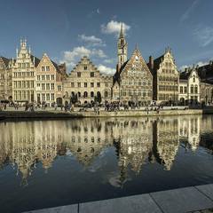 Graslei and KorenleiGhent’s medieval port, on both banks of the Leie. Boatmen unloaded grain here and the guilds built their houses along the quay. The Koornstapelhuis, the grey Romanesque grain store from around 1200, is one of the oldest houses in town.
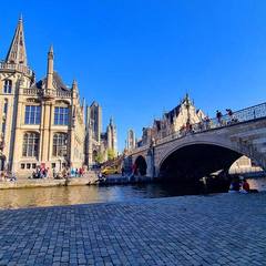 St Michael’s BridgeBuilt at the start of the 20th century, just before the 1913 World Fair. Look east to see Ghent’s three towers in a row: St Nicholas’, the Belfry and St Bavo’s. Behind you stands St Michael’s Church, whose tower was never finished.
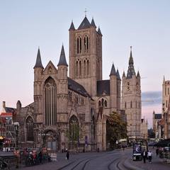 St Nicholas’ ChurchThe merchants’ church, from the 13th century, in blue-grey Tournai stone: Scheldt Gothic. Its tower sits right on the middle of the roof and doubled as a lookout, long before the Belfry stood. Today it also hosts concerts and exhibitions.
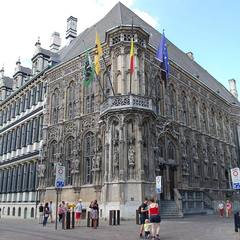 City HallA city hall in two styles: ornate late Gothic on the Hoogpoort, sober Renaissance on the Botermarkt. Running out of money and the wars of religion kept halting the building work. The Pacification of Ghent, a peace between the Low Countries’ provinces, was signed here in 1576.
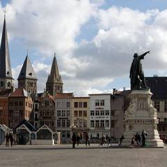 VrijdagmarktThe square of markets, feasts and uprisings, where the Counts of Flanders were sworn in. In the middle Jacob van Artevelde, the brewer who led Ghent in 1338, points the way. Across the square stands Ons Huis, the big home of the socialist workers’ movement.
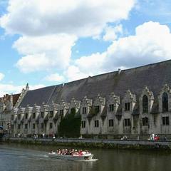 Groot VleeshuisThe butchers’ covered meat hall, built from 1406 to 1419. Hams still hang drying under its impressive wooden roof. Today you can buy and taste East Flemish regional produce here.
The centre on a map
The streets, squares and waterways every visitor to Ghent ends up in. Point at one to find it on the map.

-
1
Graslei street
The quay on the east bank of the old harbour, lined with the guild houses of the medieval merchants and boatmen.
-
2
Korenlei street
The quay across the water from the Graslei, with merchants’ houses of the 16th to 18th centuries.
-
3
The Lys Leie waterway
The river that flows through the old town to meet the Scheldt. Its stretch between the bridges was Ghent’s medieval harbour; today tour boats leave from its quays.
-
4
St Michael’s Bridge Sint-Michielsbrug bridge
The stone bridge over the Lys from which you see the Graslei, the Korenlei and the three towers of the old town in a row.
-
5
Korenmarkt square
The old corn market, a long square at the foot of St Nicholas’ Church, where trams pass and the Veldstraat begins.
-
6
Emile Braunplein square
The open square between St Nicholas’ Church and the Belfry, with the timber and glass city pavilion, the Stadshal.
-
7
Sint-Baafsplein square
The square in front of St Bavo’s Cathedral, with the Dutch Theatre (NTGent) facing it.
-
8
Botermarkt square
The old butter market, faced by the Renaissance front of the City Hall; its Gothic side looks onto the Hoogpoort.
-
9
Werregarenstraat street
A narrow alley where graffiti is allowed, painted over again and again.
-
10
Vrijdagmarkt square
The big Friday market square, for centuries the place of meetings and revolts, with a statue of Jacob van Artevelde.
-
11
Kraanlei street
A quay along the Lys with old gabled houses, named after the crane that once unloaded the boats here.
-
12
Patershol quarter
A maze of medieval lanes behind the Kraanlei, once a poor quarter of craftsmen, now full of restaurants.
-
13
Groentenmarkt square
The old vegetable market beside the long roof of the Groot Vleeshuis, the medieval meat hall.
-
14
Sint-Veerleplein square
The square in front of the Gravensteen, once the place of the town’s public executions.
-
15
Veldstraat street
Ghent’s main shopping street, running south from the Korenmarkt, free of cars.
History
Abbeys and counts
Around 630 the missionary St Amand founded two abbeys where the Lys meets the Scheldt: St Bavo’s and, on the Blandijn hill, St Peter’s. A trading town grew between them, and its name probably comes from a Celtic word for a meeting of rivers. In 879 a Viking army made its winter camp at St Bavo’s Abbey.
The counts of Flanders built a castle by the Lys to protect the town, and in 1180 Count Philip of Alsace rebuilt it in stone as the Gravensteen. Ghent grew rich on cloth, woven from English wool, and by 1300 it was one of the largest cities north of the Alps. The merchants built their guild houses along the harbour on the Graslei and the city raised the Belfry as the tower of its freedom.
Rebels and an emperor
Ghent’s weavers and merchants often defied their counts and the kings of France. In 1338 Jacob van Artevelde took charge of the city and sided with England in the Hundred Years’ War, to keep the English wool coming. In 1432 Hubert and Jan van Eyck finished the Ghent Altarpiece for the church of St John, today St Bavo’s Cathedral.
Charles V, who would rule half of Europe, was born in Ghent’s Prinsenhof in 1500. When his native city refused to pay his taxes and revolted, he came back in 1540, took away its privileges and made its leading citizens beg for mercy barefoot, with nooses around their necks; the people of Ghent still call themselves the noose-bearers, the stroppendragers. In 1576 the Pacification of Ghent briefly united the Low Countries against the Spanish troops of his son, Philip II.
Manchester of the Continent
Around 1800 Lieven Bauwens smuggled a spinning machine out of England and set up machine spinning in Ghent. Cotton and flax mills followed, and the city became the most industrial in Belgium, the ‘Manchester of the Continent’, with crowded workers’ quarters and a strong socialist movement. In 1814 British and American diplomats signed the Treaty of Ghent here to end the War of 1812, and in 1817 King William I founded the university.
Ghent held a World’s Fair in 1913, and in 1930 its university became the first in Belgium to teach in Dutch. When the textile mills closed in the 20th century, the port, a steel works and a car factory took their place. The old centre, long grey with soot, was cleaned and restored, and in 2017 the city closed it to through traffic.
Ghent today
Ghent is the second-largest city of Flanders, after Antwerp. Its port, its steel works and its car factory still employ thousands, but the university and its tens of thousands of students set the tone of the city. The town council has pushed cars out of the centre and bicycles into it, and in 2009 it became one of the first cities to promote a meat-free Thursday.
Every July the Gentse Feesten fill the squares of the old town with free concerts and street theatre for ten days. Ghent people eat waterzooi, a creamy stew of chicken or fish, and buy cuberdons, the purple ‘noses’ of raspberry syrup, from carts on the Groentenmarkt.
Read on
- Visit Gent The city’s official tourist information
- City of Ghent The city council
- Belfries of Belgium and France on UNESCO The World Heritage listing that includes Ghent’s Belfry
- Flemish Béguinages on UNESCO The World Heritage listing that includes Ghent’s two béguinages
- Ghent on Wikipedia The encyclopedia article